|
Ideal Radial Pattern-concentric zone
|
Economic Effects-bid rent function
|
Spatial Organization Concept
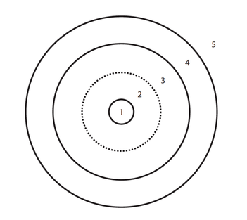
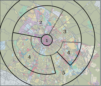
In general, Lexington’s layout can be explained by “concentric zones” theory. The circular zones show that the influence of a large city center over its surrounding area diminishes with increasing distance. Social differentiation, which is polarized toward the city center, can be demonstrated by comparing the average of a social indicator such as poverty for all of circular zones. The trend line of these averages give a gradient pattern reflecting the spatial structure of land use within the city that is determined by the accessibility needs and preferences of firms and households. Aside from the loop containing the central business district, the rings of the city are characterized by income-level residential land uses. Thus, the second zone, or zone of transition, contains poor and old residential property and run-down areas that have been invaded by business and light manufacturing as the CBD expands. The third zone, that of workingmen’s home, includes residences in close proximity with industrial plants. These homes have the double advantage of low rents and ease of commuting to work. The forth zone is a high-class residential area, while the fifth is one of residential suburbs and satellite development within commuting distance to the central city. As growth occurs, each zone tends to extend its area by invading the next outer zone in an “invasion-succession” sequence. If, one the other hand, there is a decline of population, the outer zones tend to remain stationary while the transitional zone recedes into loop thereby creating commercial and residential slums.
However, certain areas are invading other zones, such as an exclusive residential is located within urban boundary where has an access to a lake view. This can be explained by economic theory instead of sociological theory. A piece of land with competitive advantages attracts bidders and high-class residents. This land might not fall in a supposed ring and follow a radial pattern. Viewing the radial sector theory from the residential location point of view, there is, first of all, excessive emphasis given to the high- income group’s importance in dictating pattern of urban expansion and residential relocation. [12]
Source: google earth
